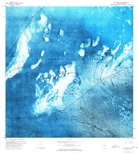
1971 Map of Dry Tortugas
USGS Topo · Published 1973About this map
Garden Key serves as the focal point of this orthophotomap, dominated by the massive hexagonal structure of Fort Jefferson. As part of the Fort Jefferson National Monument, the island complex includes several Ruins and a designated Campground. The surrounding waters of the Gulf of Mexico are partitioned by deep-water passages such as the Northwest Channel and Southeast Channel, which provide access through the complex of keys and shoals.
Find a feature on this map
25 named features on this map. Tap any name to fly to it.
Don’t see what you’re looking for? This feature index may not catch every label — zoom into the map to look around manually.
Map Details
Editions of this 1971 Dry Tortugas Map
This is the sole edition of this map. No revisions or reprints were ever made.
Other maps of this area

1983 · Dry Tortugas
USGS Topo · 1:100,000

1989 · Dry Tortugas
USGS Topo · 1:250,000
2012 · Dry Tortugas
USGS Topo · 1:24,000
2012 · Dry Tortugas OE S
USGS Topo · 1:24,000
2012 · Dry Tortugas OE E
USGS Topo · 1:24,000
2012 · Dry Tortugas OE SE
USGS Topo · 1:24,000
2015 · Dry Tortugas OE SE
USGS Topo · 1:24,000
2015 · Dry Tortugas OE E
USGS Topo · 1:24,000
2015 · Dry Tortugas OE S
USGS Topo · 1:24,000

2015 · Dry Tortugas
USGS Topo · 1:24,000