
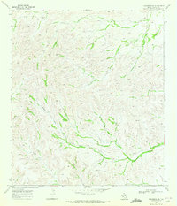
1969 Map of Dryden NW
USGS Topo · Published 1972About this map
Arid ranchlands of Terrell County define this 1969 topographic survey, where isolated outposts like Wood Ranch and Mitchell Ranch stand against a complex network of dry watercourses. The drainage patterns of Eightmile Draw and Downie Draw dominate the landscape, carving deep relief through the Trans-Pecos terrain. Evidence of the mid-century cattle industry is visible through the fine red dashed lines indicating fence lines and the presence of an earthen Landing Strip, likely used for ranching operations and aerial surveillance of this remote territory. These features illustrate the adaptations required for large-scale livestock operations in West Texas, where water management and long-distance transport were essential for survival. Researchers and genealogists can trace the footprint of the Odom Ranch and other family-held lands as they appeared before modern changes to the regional infrastructure.
Find a feature on this map
6 named features on this map. Tap any name to fly to it.
Don’t see what you’re looking for? This feature index may not catch every label — zoom into the map to look around manually.
Map Details
Editions of this 1969 Dryden NW Map
This is the sole edition of this map. No revisions or reprints were ever made.
Other maps of this area

1928 · Sanderson
USGS Topo · 1:125,000

1954 · Fort Stockton
USGS Topo · 1:250,000

1958 · Fort Stockton
USGS Topo · 1:250,000

1968 · Dryden
USGS Topo · 1:24,000

1969 · Sanderson SE
USGS Topo · 1:24,000

1969 · Big Canyon Ranch
USGS Topo · 1:24,000

1969 · Mofeta
USGS Topo · 1:24,000

1969 · Continental Ranch
USGS Topo · 1:24,000

1969 · Dryden NE
USGS Topo · 1:24,000
1969 · Sanderson NE
USGS Topo · 1:24,000