
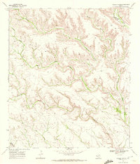
1969 Map of Sanderson SE
USGS Topo · Published 1972About this map
Sanderson Canyon and the winding course of Sanderson Creek define this West Texas landscape during the late 1960s. The topography is dominated by steep-walled drainages, including Seminole Canyon and Rock Ravine Canyon, which illustrate the arid, dissected plateau of Terrell County. Human presence is concentrated at remote outposts such as Harrell Ranch and Carruthers Ranch, highlighting the region's long-standing reliance on large-scale ranching operations. The Southern Pacific railroad cuts through the north, following the natural grades provided by the canyon systems. This infrastructure, along with isolated landmarks like a Water Tank and Corral, provides a clear view of the logistical requirements for both transportation and livestock management in this sparsely populated territory.
Find a feature on this map
9 named features on this map. Tap any name to fly to it.
Don’t see what you’re looking for? This feature index may not catch every label — zoom into the map to look around manually.
Map Details
Editions of this 1969 Sanderson SE Map
This is the sole edition of this map. No revisions or reprints were ever made.
Other maps of this area

1918 · Dryden Crossing
USGS Topo · 1:62,500

1918 · Indian Wells
USGS Topo · 1:62,500

1928 · Sanderson
USGS Topo · 1:125,000

1954 · Fort Stockton
USGS Topo · 1:250,000

1958 · Fort Stockton
USGS Topo · 1:250,000

1959 · Emory Peak
USGS Topo · 1:250,000

1965 · Emory Peak
USGS Topo · 1:250,000

1969 · Sanderson
USGS Topo · 1:24,000

1969 · Mofeta
USGS Topo · 1:24,000
1969 · Hagler Canyon
USGS Topo · 1:24,000