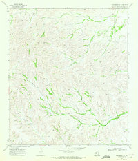
1969 Map of Sanderson NE
USGS Topo · Published 1972About this map
Brown Ranch sits in the high plateau country of Terrell County, surrounded by the complex drainage systems characteristic of the Trans-Pecos region in the late 1960s. The landscape is defined by the winding path of Eightmile Draw, which cuts through the terrain as the primary topographical landmark of the quadrangle. As a working ranch landscape, the area is dotted with essential water infrastructure including several instances of a Water Tank, such as Water Tank 3371 and Water Tank 2922. A single Corral located near the southern reaches of the draw provides a specific point of interest for those tracing the history of Texas livestock operations. This 1969 field-checked survey reveals the functional layout of a remote ranching station where terrain and water access dictated every aspect of human settlement and land use.
Find a feature on this map
7 named features on this map. Tap any name to fly to it.
Don’t see what you’re looking for? This feature index may not catch every label — zoom into the map to look around manually.
Map Details
Editions of this 1969 Sanderson NE Map
This is the sole edition of this map. No revisions or reprints were ever made.
Other maps of this area

1928 · Sanderson
USGS Topo · 1:125,000

1954 · Fort Stockton
USGS Topo · 1:250,000

1958 · Fort Stockton
USGS Topo · 1:250,000

1969 · Sanderson SE
USGS Topo · 1:24,000

1969 · Sanderson
USGS Topo · 1:24,000

1969 · Big Canyon Ranch
USGS Topo · 1:24,000

1969 · Mofeta
USGS Topo · 1:24,000
1969 · Big Canyon Ranch SW
USGS Topo · 1:24,000
1969 · Hagler Canyon
USGS Topo · 1:24,000

1969 · Dryden NW
USGS Topo · 1:24,000