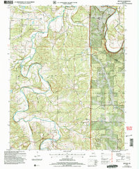
2004 Map of Drynob
USGS Topo · Published 2006About this map
The Osage Fork and Gasconade River converge in this corner of the Ozark Plateau, where the landscape is defined by deep hollows and narrow ridge tops. Rural life in the mid-twentieth century and into the early 2000s is recorded through the distribution of family-named cemeteries and small community hubs like Abo and Drynob. The presence of Prairie Creek Sch (Site) and Mount Salem Sch (Site) points to a shifting demographic, documenting the locations of former local schools that once anchored the area. This transition is further reflected in the inclusion of the Mark Twain National Forest, which covers a significant portion of the eastern terrain. Numerous cemeteries, including Smilin Cem and Wrinkle Cem, offer vital locations for genealogical research in Laclede and Pulaski counties, while the Hull Ford Bridge remains a key crossing over the winding waterways.
Find a feature on this map
32 named features on this map. Tap any name to fly to it.
Don’t see what you’re looking for? This feature index may not catch every label — zoom into the map to look around manually.
Map Details
Editions of this 2004 Drynob Map
This is the sole edition of this map. No revisions or reprints were ever made.
Other maps of this area

1933 · Stoutland
USGS Topo · 1:62,500

1938 · Stoutland
USGS Topo · 1:62,500

1941 · Lebanon
USGS Topo · 1:62,500

1943 · Richland
USGS Topo · 1:62,500

1943 · Lebanon
USGS Topo · 1:62,500

1943 · Drynob
USGS Topo · 1:62,500

1954 · Springfield
USGS Topo · 1:250,000

1954 · Drynob
USGS Topo · 1:62,500
1954 · Richland
USGS Topo · 1:62,500

1954 · Drew
USGS Topo · 1:24,000