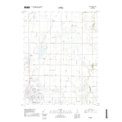
2018 Map of Du Quoin
USGS Topo · Published 2018About this map
Du Quoin serves as the primary hub of activity on this Perry County landscape, where the southern Illinois prairie is deeply etched by the drainage of Reese Cr and Little Muddy River. The map details a transition from the structured residential grid of the city to the expansive agricultural tracts and timbered creek bottoms that define the surrounding countryside. This survey captures a rural landscape heavily punctuated by its heritage, evidenced by numerous burial grounds like Paradise Prairie Cem and the Independent Order of Oddfellows Cem. Industrial and recreational waters, including Du Quoin Lake and Cherry Lake, are central to the terrain. Along the eastern boundary, the Little Muddy River meanders sharply, crossed by landmarks such as the Jackson Bridge, while smaller settlements like Sunfield and St. Johns remain distinct nodes along the main transport corridors.
Find a feature on this map
123 named features on this map. Tap any name to fly to it.
Don’t see what you’re looking for? This feature index may not catch every label — zoom into the map to look around manually.
Map Details
Editions of this 2018 Du Quoin Map
This is the sole edition of this map. No revisions or reprints were ever made.
Other maps of this area

1910 · Herrin
USGS Topo · 1:62,500

1910 · Murphysboro
USGS Topo · 1:62,500

1924 · Pinckneyville
USGS Topo · 1:62,500

1926 · Pinckneyville
USGS Topo · 1:62,500

1926 · Duquoin
USGS Topo · 1:62,500

1936 · Herrin
USGS Topo · 1:62,500

1938 · Murphysboro
USGS Topo · 1:62,500

1949 · Paducah
USGS Topo · 1:250,000

1950 · Paducah
USGS Topo · 1:250,000

1954 · Paducah
USGS Topo · 1:250,000