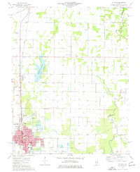
1975 Map of Du Quoin
USGS Topo · Published 1977About this map
The Tamaroa South Oil Field dominates the northern landscape of this mid-1970s survey, illustrating the industrial character of rural Perry County. The city of Du Quoin serves as the central hub, where the Illinois Central Gulf railroad supports a complex of local institutions, including Browning Hospital and several neighborhood schools like McKinley Sch and Ward Sch. This era captures a mix of extraction and community infrastructure, with a Strip Mine and Mine Dump visible near Sunfield.
Find a feature on this map
43 named features on this map. Tap any name to fly to it.
Don’t see what you’re looking for? This feature index may not catch every label — zoom into the map to look around manually.
Map Details
Editions of this 1975 Du Quoin Map
This is the sole edition of this map. No revisions or reprints were ever made.
Other maps of this area

1910 · Herrin
USGS Topo · 1:62,500

1910 · Murphysboro
USGS Topo · 1:62,500

1924 · Pinckneyville
USGS Topo · 1:62,500

1926 · Pinckneyville
USGS Topo · 1:62,500

1926 · Duquoin
USGS Topo · 1:62,500

1936 · Herrin
USGS Topo · 1:62,500

1938 · Murphysboro
USGS Topo · 1:62,500

1949 · Paducah
USGS Topo · 1:250,000

1950 · Paducah
USGS Topo · 1:250,000

1954 · Paducah
USGS Topo · 1:250,000