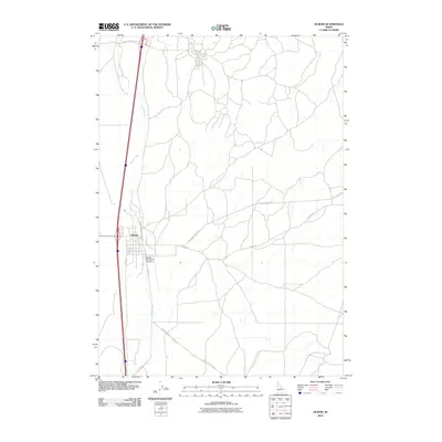
2010 Map of Dubois
USGS Topo · Published 2010About this map
Dubois serves as the focal point of this eastern Idaho landscape, situated along the corridor where Interstate 15 and Old Hwy 91 parallel the winding course of Beaver Creek. The town's grid is clearly defined by local thoroughfares such as Idaho St and Reynolds St, supporting a community tied to the region's agricultural and transportation sectors. To the south, the Dubois Municipal Airport provides a key link for this high-plains area, while the surrounding territory is marked by a network of rural routes including A-2 Clark County Rd and Jacoby Rd. The presence of the US Sheep Experiment Station Rd at the northern edge reflects the long-standing scientific research heritage characteristic of this portion of Clark County.
Find a feature on this map
10 named features on this map. Tap any name to fly to it.
Don’t see what you’re looking for? This feature index may not catch every label — zoom into the map to look around manually.
Map Details
Editions of this 2010 Dubois Map
This is the sole edition of this map. No revisions or reprints were ever made.
Other maps of this area

1955 · Dubois
USGS Topo · 1:250,000

1957 · Paul Reservoir
USGS Topo · 1:62,500

1958 · Dubois
USGS Topo · 1:250,000

1964 · Dubois NW
USGS Topo · 1:24,000

1964 · Lone Butte
USGS Topo · 1:24,000

1964 · Dubois NE
USGS Topo · 1:24,000

1964 · Camas
USGS Topo · 1:24,000
1964 · Dubois SE
USGS Topo · 1:24,000

1964 · Cedar Butte SE
USGS Topo · 1:24,000

1972 · Spencer South
USGS Topo · 1:24,000