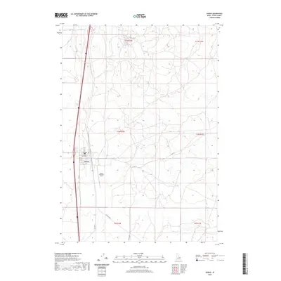
2020 Map of Dubois
USGS Topo · Published 2020About this map
Dubois serves as the focal point of this Clark County survey, anchored by the Clark County Courthouse at the intersection of local routes like Thomas Ave and Idaho St. The town's grid is concentrated west of Beaver Cr, which threads south through the landscape alongside modern transportation corridors and remnants of older routes like Old Hwy 91. To the south and east of the main settlement, the Dubois Municipal Airport occupies a flat expanse, while the surrounding high desert terrain is punctuated by a network of ranch roads including Jacoby Rd, Laird Rock Rd, and Lamb Shed Rd. This layout reflects a quintessential Western crossroads where civic administration, aviation, and agriculture converge in a high-elevation environment.
Find a feature on this map
21 named features on this map. Tap any name to fly to it.
Don’t see what you’re looking for? This feature index may not catch every label — zoom into the map to look around manually.
Map Details
Editions of this 2020 Dubois Map
This is the sole edition of this map. No revisions or reprints were ever made.
Other maps of this area

1955 · Dubois
USGS Topo · 1:250,000

1957 · Paul Reservoir
USGS Topo · 1:62,500

1958 · Dubois
USGS Topo · 1:250,000

1964 · Dubois NW
USGS Topo · 1:24,000

1964 · Lone Butte
USGS Topo · 1:24,000

1964 · Dubois NE
USGS Topo · 1:24,000

1964 · Camas
USGS Topo · 1:24,000
1964 · Dubois SE
USGS Topo · 1:24,000

1964 · Cedar Butte SE
USGS Topo · 1:24,000

1972 · Spencer South
USGS Topo · 1:24,000