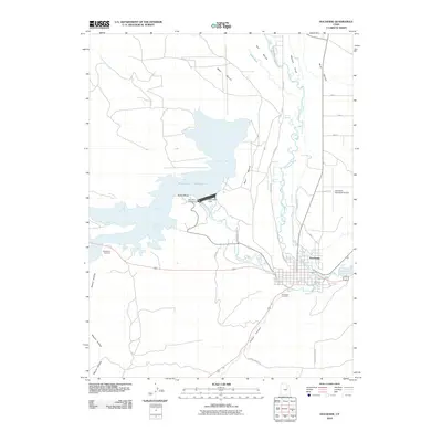
2010 Map of Duchesne
USGS Topo · Published 2010About this map
Duchesne sits at the confluence of the Strawberry River and the Duchesne River, serving as a focal point for water management and transit in the Uinta Basin. The landscape is dominated by the large expanse of the Starvation Reservoir, held by the Starvation Dam at Pulley Bend. This engineering project fundamentally altered the local topography, creating the Starvation Campground and surrounding recreational areas.
Find a feature on this map
29 named features on this map. Tap any name to fly to it.
Don’t see what you’re looking for? This feature index may not catch every label — zoom into the map to look around manually.
Map Details
Editions of this 2010 Duchesne Map
This is the sole edition of this map. No revisions or reprints were ever made.
Other maps of this area

1885 · Uinta
USGS Topo · 1:250,000

1939 · Duchesne
USGS Topo · 1:125,000

1954 · Salt Lake City
USGS Topo · 1:250,000

1958 · Salt Lake City
USGS Topo · 1:250,000

1960 · Salt Lake City
USGS Topo · 1:250,000
1962 · Buck Knoll
USGS Topo · 1:24,000

1962 · Blacktail Mtn
USGS Topo · 1:24,000

1962 · Rabbit Gulch
USGS Topo · 1:24,000
1964 · Duchesne SE
USGS Topo · 1:24,000
1964 · Duchesne SW
USGS Topo · 1:24,000