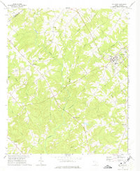
1971 Map of Due West
USGS Topo · Published 1975About this map
Erskine College serves as the cultural and geographic anchor of this South Carolina landscape, centered in the town of Due West. The surrounding rural territory in Abbeville County and Anderson County is defined by a dense network of country churches and small community hubs like Level Land and Fairs Crossroads. These social centers, including Little River Ch, Friendship Ch, and St Marys Ch, were often established near the many waterways draining toward the Little River, such as Hogskin Creek and Chickasaw Creek. The map documents a traditional agricultural and educational landscape in the early 1970s, where small settlements like Buck Stand and landmarks like Little Mountain break the undulating terrain. Local education is well-represented through Dixie High Sch and the Carver Sch, illustrating the dispersed yet connected nature of the Upstate South Carolina piedmont during this era.
Find a feature on this map
27 named features on this map. Tap any name to fly to it.
Don’t see what you’re looking for? This feature index may not catch every label — zoom into the map to look around manually.
Map Details
Editions of this 1971 Due West Map
This is the sole edition of this map. No revisions or reprints were ever made.
Other maps of this area

1892 · Abbeville
USGS Topo · 1:125,000

1893 · Elberton
USGS Topo · 1:125,000

1948 · Abbeville East
USGS Topo · 1:24,000

1948 · Abbeville West
USGS Topo · 1:24,000

1949 · Abbeville
USGS Topo · 1:24,000

1950 · Abbeville East
USGS Topo · 1:24,000

1954 · Greenville
USGS Topo · 1:250,000

1958 · Greenville
USGS Topo · 1:250,000

1964 · Antreville
USGS Topo · 1:24,000

1964 · Saylors Crossroads
USGS Topo · 1:24,000