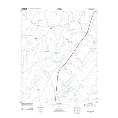
2011 Map of Dugout Valley
USGS Topo · Published 2011About this map
Pea Ridge and the winding course of Town Creek dominate this corner of DeKalb County, where the topography of the Appalachian plateau dictates the local road network. The landscape is dotted with small, dispersed communities such as New Home, Stamp, and High Point, alongside established family landmarks like McCurdy Bridge and Hammond Gap. For genealogists, the map is particularly valuable for identifying historic burial grounds, including Cordell Cemetery and White Hall Cemetery, which are tucked away from the main thoroughfares. In the south, the expansion of Fort Payne City Lake and the settlement at Lakewood reflect the area's development near the county seat. The importance of the regional gaps is evident at Bethel Gap and Snake Gap, natural corridors that have long facilitated movement through this corner of Alabama.
Find a feature on this map
120 named features on this map. Tap any name to fly to it.
Don’t see what you’re looking for? This feature index may not catch every label — zoom into the map to look around manually.
Map Details
Editions of this 2011 Dugout Valley Map
This is the sole edition of this map. No revisions or reprints were ever made.
Other maps of this area

1886 · Stevenson
USGS Topo · 1:125,000

1892 · Stevenson
USGS Topo · 1:125,000

1893 · Fort Payne
USGS Topo · 1:125,000

1895 · Stevenson
USGS Topo · 1:125,000

1898 · Fort Payne
USGS Topo · 1:125,000

1900 · Fort Payne
USGS Topo · 1:125,000

1936 · Ider
USGS Topo · 1:24,000

1936 · Dugout Valley
USGS Topo · 1:24,000

1936 · Chavies
USGS Topo · 1:24,000

1936 · Sulphur Springs
USGS Topo · 1:24,000