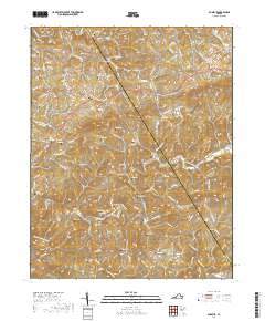
2019 Map of Dugspur
USGS Topo · Published 2019About this map
Dugspur serves as a focal point in this upland region of the Blue Ridge, where the landscape is defined by a dense network of family cemeteries and winding creek valleys. The boundary between Floyd Co and Carroll Co cuts diagonally across the terrain, separating the headwaters of numerous streams including Mira Fork, Burks Fork, and Greasy Cr. This survey provides a remarkably detailed record for genealogists, documenting dozens of small burial grounds such as the Ezra Marshall Cem, Mitchell Chapel Cem, and Annis Goad Cem that are often the only remaining physical markers of early family homesteads. The topography is dominated by Indian Ridge, with roads like Floyd Pike and Indian Valley Rd following the natural contours of the land between Big Reed Island Creek and Laurel Fork.
Find a feature on this map
129 named features on this map. Tap any name to fly to it.
Don’t see what you’re looking for? This feature index may not catch every label — zoom into the map to look around manually.
Map Details
Editions of this 2019 Dugspur Map
This is the sole edition of this map. No revisions or reprints were ever made.
Other maps of this area

1889 · Hillsville
USGS Topo · 1:125,000

1892 · Hillsville
USGS Topo · 1:125,000

1896 · Hillsville
USGS Topo · 1:125,000

1928 · Stuart
USGS Topo · 1:48,000

1931 · Stuart
USGS Topo · 1:62,500

1953 · Winston-Salem
USGS Topo · 1:250,000

1955 · Winston-Salem
USGS Topo · 1:250,000

1956 · Macks Mountain
USGS Topo · 1:62,500

1957 · Mount Airy
USGS Topo · 1:62,500

1957 · Floyd
USGS Topo · 1:62,500