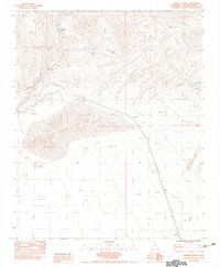
1983 Map of Dumont Dunes
USGS Topo · Published 1983About this map
The Old Railroad Grade traces a path through the arid San Bernardino desert, marking the industrial legacy of this remote corridor. This 1983 provisional survey shows a landscape defined by shifting sands and the dry course of the Amargosa River. Two historical points of interest, Sperry (Site) near Sperry Wash and Dumont (Site) to the southeast, represent the vanished infrastructure that once supported movement through these dunes. The terrain is dominated by the striking formations of the Dumont Dunes and Valjean Dunes, which are framed by the Dumont Hills and Valjean Hills. The map serves as a precise record of the desert's topography and historical transportation routes before further modernization, focusing on the preservation of these site names and the former rail path.
Find a feature on this map
9 named features on this map. Tap any name to fly to it.
Don’t see what you’re looking for? This feature index may not catch every label — zoom into the map to look around manually.
Map Details
Editions of this 1983 Dumont Dunes Map
2 editions found
Other maps of this area

1933 · Avawatz Mountains
USGS Topo · 1:250,000

1947 · Trona
USGS Topo · 1:250,000

1948 · Trona
USGS Topo · 1:250,000

1948 · Avawatz Pass
USGS Topo · 1:62,500

1950 · Tecopa
USGS Topo · 1:62,500

1951 · Avawatz Pass
USGS Topo · 1:62,500

1951 · Tecopa
USGS Topo · 1:62,500

1951 · Shoshone
USGS Topo · 1:62,500

1953 · Trona
USGS Topo · 1:250,000

1956 · Silurian Hills
USGS Topo · 1:62,500