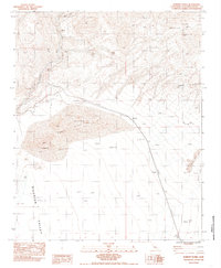
1983 Map of Dumont Dunes
USGS Topo · Published 1985About this map
Sperry (Site) and Dumont (Site) are captured here as former outposts along the Old Railroad Grade in the Mojave Desert. The landscape is defined by the stark movement of wind and water, where the ephemeral Amargosa River cuts through the wide Silurian Valley and Sperry Wash drains from the north. The survey provides a detailed look at the shifting topography of the Dumont Dunes and the smaller Valjean Dunes, which rise between the rocky outcrops of the Dumont Hills and Valjean Hills. This map documents a transitional period when former industrial corridors were being reclaimed by the desert sands, preserving the location of markers like Uslm and several SJ survey points used to navigate this arid basin during the early 1980s.
Find a feature on this map
14 named features on this map. Tap any name to fly to it.
Don’t see what you’re looking for? This feature index may not catch every label — zoom into the map to look around manually.
Map Details
Editions of this 1983 Dumont Dunes Map
2 editions found
Other maps of this area

1933 · Avawatz Mountains
USGS Topo · 1:250,000

1947 · Trona
USGS Topo · 1:250,000

1948 · Trona
USGS Topo · 1:250,000

1948 · Avawatz Pass
USGS Topo · 1:62,500

1950 · Tecopa
USGS Topo · 1:62,500

1951 · Avawatz Pass
USGS Topo · 1:62,500

1951 · Tecopa
USGS Topo · 1:62,500

1951 · Shoshone
USGS Topo · 1:62,500

1953 · Trona
USGS Topo · 1:250,000

1956 · Silurian Hills
USGS Topo · 1:62,500