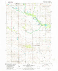
1979 Map of Dumont South
USGS Topo · Published 1986About this map
The West Fork Cedar River and its numerous tributaries, including Hartgrave Creek and Maynes Creek, define the topography of this central Iowa landscape. The Chicago and North Western railroad cuts diagonally across the terrain, linking the communities of Dumont and Kesley. This rail-oriented corridor supported a local economy of agriculture and extraction, evidenced by various Gravel Pits and a Quarry scattered near the watercourses.
Find a feature on this map
25 named features on this map. Tap any name to fly to it.
Don’t see what you’re looking for? This feature index may not catch every label — zoom into the map to look around manually.
Map Details
Editions of this 1979 Dumont South Map
2 editions found
Other maps of this area

1954 · Waterloo
USGS Topo · 1:250,000

1955 · Waterloo
USGS Topo · 1:250,000

1972 · Dumont North
USGS Topo · 1:24,000

1972 · Hansell
USGS Topo · 1:24,000

1972 · Allison
USGS Topo · 1:24,000

1979 · Ackley NE
USGS Topo · 1:24,000

1979 · Ackley
USGS Topo · 1:24,000

1979 · Dumont South
USGS Topo · 1:24,000

1979 · Butler Center
USGS Topo · 1:24,000

1980 · Aplington
USGS Topo · 1:24,000