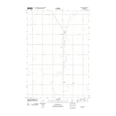
2010 Map of Dumont
USGS Topo · Published 2010About this map
Dumont serves as the central hub of this agricultural landscape in Traverse County, characterized by a highly organized grid of rural roads and drainage infrastructure. The settlement pattern is anchored by the Dumont Post Office, while the surrounding prairie is divided by precisely surveyed routes like County Hwy-6 and County Hwy-9. Water management is a defining feature of the terrain, with County Ditch Number Fifteen and the meandering path of West Branch Twelvemile Creek illustrating the transition of the native prairie into productive farmland. To the south, the small community of Collis and the Saint Patrick Cemetery provide important points of reference for local family history and genealogy. The presence of Frisch Airport west of the creek highlights the continued importance of regional aviation in supporting this remote farming district.
Find a feature on this map
20 named features on this map. Tap any name to fly to it.
Don’t see what you’re looking for? This feature index may not catch every label — zoom into the map to look around manually.
Map Details
Editions of this 2010 Dumont Map
This is the sole edition of this map. No revisions or reprints were ever made.
Other maps of this area

1915 · White Rock
USGS Topo · 1:62,500

1916 · Beardsley
USGS Topo · 1:62,500

1918 · White Rock
USGS Topo · 1:62,500

1918 · Beardsley
USGS Topo · 1:62,500

1950 · Graceville
USGS Topo · 1:62,500

1951 · Wheaton
USGS Topo · 1:62,500

1953 · Milbank
USGS Topo · 1:250,000

1958 · Milbank
USGS Topo · 1:250,000
1972 · Wheaton West
USGS Topo · 1:24,000
1974 · Graceville NE
USGS Topo · 1:24,000