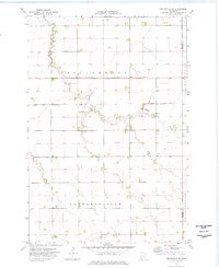
1974 Map of Graceville NE
USGS Topo · Published 1976About this map
Twelvemile Creek meanders across this rural section of the Minnesota prairie, defining a landscape dominated by the large agricultural townships of Dollymount and Leonardsville. Surveyed in the early 1970s, the map reveals a highly managed hydrological system where the natural flow of the West Fork and East Fork is integrated with an extensive network of man-made channels, including County Ditch No 37 and County Ditch No 33.
Find a feature on this map
13 named features on this map. Tap any name to fly to it.
Don’t see what you’re looking for? This feature index may not catch every label — zoom into the map to look around manually.
Map Details
Editions of this 1974 Graceville NE Map
This is the sole edition of this map. No revisions or reprints were ever made.
Other maps of this area

1910 · Chokio
USGS Topo · 1:62,500

1911 · Herman
USGS Topo · 1:62,500

1912 · Chokio
USGS Topo · 1:62,500

1950 · Graceville
USGS Topo · 1:62,500

1951 · Wheaton
USGS Topo · 1:62,500

1953 · Milbank
USGS Topo · 1:250,000

1958 · Milbank
USGS Topo · 1:250,000
1973 · Herman
USGS Topo · 1:24,000
1973 · Chokio NW
USGS Topo · 1:24,000
1973 · Chokio
USGS Topo · 1:24,000