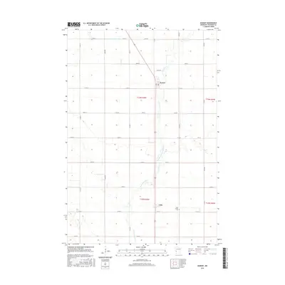
2016 Map of Dumont
USGS Topo · Published 2016About this map
Dumont and the smaller settlement of Collis anchor this agricultural landscape in Traverse County, defined by a rigid grid of section roads and drainage improvements. The geography is shaped by the West Branch Twelvemile Creek, which meanders southward toward Collis, where it is also labeled as W Br Twelvemile Cr. This drainage network is supplemented by engineered waterways like County Ditch Number Fifteen, reflecting the region's managed water systems. For those researching local history, the Saint Patrick Cem stands as a significant landmark east of Collis, serving as a primary site for genealogical study in this sparsely populated township. The area remains dominated by large-scale farming, with the road network including Co Hwy 4 and Co Hwy 9 facilitating transit through the township lines.
Find a feature on this map
34 named features on this map. Tap any name to fly to it.
Don’t see what you’re looking for? This feature index may not catch every label — zoom into the map to look around manually.
Map Details
Editions of this 2016 Dumont Map
This is the sole edition of this map. No revisions or reprints were ever made.
Other maps of this area

1915 · White Rock
USGS Topo · 1:62,500

1916 · Beardsley
USGS Topo · 1:62,500

1918 · White Rock
USGS Topo · 1:62,500

1918 · Beardsley
USGS Topo · 1:62,500

1950 · Graceville
USGS Topo · 1:62,500

1951 · Wheaton
USGS Topo · 1:62,500

1953 · Milbank
USGS Topo · 1:250,000

1958 · Milbank
USGS Topo · 1:250,000
1972 · Wheaton West
USGS Topo · 1:24,000
1974 · Graceville NE
USGS Topo · 1:24,000