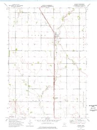
1974 Map of Dumont
USGS Topo · Published 1976About this map
The Chicago Milwaukee St Paul and Pacific railroad forms a dominant north-south spine through this portion of Traverse County, anchoring the small agricultural settlements of Dumont and Collis. The landscape is defined by the engineered drainage of the Red River Valley, where the natural course of West Branch Twelvemile Creek is supplemented by an extensive network of man-made channels including County Ditch No 31 and County Ditch No 44. These ditches reflect the mid-century intensification of farming across the townships of Croke, Tara, and Leonardsville. Local landmarks such as the St Patrick Cem and a small Landing Strip south of Dumont provide specific points of interest for genealogists and local historians. The presence of several Gravel Pits along the creek line indicates the glacial origins of the local topography, which stays largely flat until reaching the basin of Saint Marys Lake at the southern edge.
Find a feature on this map
19 named features on this map. Tap any name to fly to it.
Don’t see what you’re looking for? This feature index may not catch every label — zoom into the map to look around manually.
Map Details
Editions of this 1974 Dumont Map
This is the sole edition of this map. No revisions or reprints were ever made.
Other maps of this area

1915 · White Rock
USGS Topo · 1:62,500

1916 · Beardsley
USGS Topo · 1:62,500

1918 · White Rock
USGS Topo · 1:62,500

1918 · Beardsley
USGS Topo · 1:62,500

1950 · Graceville
USGS Topo · 1:62,500

1951 · Wheaton
USGS Topo · 1:62,500

1953 · Milbank
USGS Topo · 1:250,000

1958 · Milbank
USGS Topo · 1:250,000
1972 · Wheaton West
USGS Topo · 1:24,000
1974 · Graceville NE
USGS Topo · 1:24,000