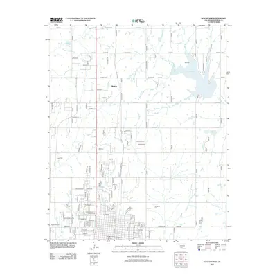
2012 Map of Duncan North
USGS Topo · Published 2012About this map
Marlow serves as a primary geographic anchor in this 2012 survey of Stephens County, where the transition from residential grids to rural creek valleys defines the landscape. The northern edge of the map is dominated by the sprawling waters of Lake Humphreys, while the southern reaches move toward the industrial and transport hubs including the Copland Airport. This era of the region’s development is marked by a mix of well-established cemeteries and modern water management features like the Wildhorse Creek Site 20 Reservoir.
Find a feature on this map
158 named features on this map. Tap any name to fly to it.
Don’t see what you’re looking for? This feature index may not catch every label — zoom into the map to look around manually.
Map Details
Editions of this 2012 Duncan North Map
This is the sole edition of this map. No revisions or reprints were ever made.
Other maps of this area

1901 · Addington
USGS Topo · 1:125,000

1902 · Rush Springs
USGS Topo · 1:125,000

1949 · Nellie
USGS Topo · 1:62,500

1950 · Marlow
USGS Topo · 1:62,500

1951 · Marlow
USGS Topo · 1:62,500

1955 · Lawton
USGS Topo · 1:250,000
1956 · Denton
USGS Topo · 1:24,000

1956 · Nellie
USGS Topo · 1:24,000

1956 · Nellie
USGS Topo · 1:62,500

1957 · Ardmore
USGS Topo · 1:250,000