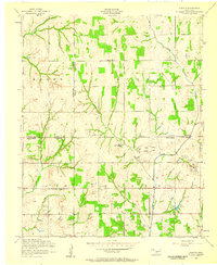
1956 Map of Denton
USGS Topo · Published 1959About this map
Denton and the surrounding rangelands of southwestern Oklahoma appear here in the mid-1950s, a landscape defined by the intersection of agricultural roots and the emerging energy economy. The map reveals a rural society structured around local gathering points like the Hurley Grove Community House, Woodlawn Church, and the schoolrooms of Starr School and Beaver School. This period marks a significant transition as an extensive Oil and Gas Field begins to dominate the central terrain, with numerous Oil wells and Slush tanks appearing alongside established watercourses like Little Beaver Creek and Cottonwood Creek. The survey clearly delineates the complex county boundaries where Comanche, Grady, and Stephens counties meet, providing a precise record of property and political lines just as industrial oil extraction was reshaping the Oklahoma prairie.
Find a feature on this map
21 named features on this map. Tap any name to fly to it.
Don’t see what you’re looking for? This feature index may not catch every label — zoom into the map to look around manually.
Map Details
Editions of this 1956 Denton Map
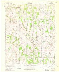
2 editions found
Other maps of this area

1902 · Rush Springs
USGS Topo · 1:125,000

1949 · Cement
USGS Topo · 1:62,500

1949 · Nellie
USGS Topo · 1:62,500

1949 · Rush Springs
USGS Topo · 1:62,500

1950 · Rush Springs
USGS Topo · 1:62,500

1950 · Marlow
USGS Topo · 1:62,500

1951 · Marlow
USGS Topo · 1:62,500

1955 · Lawton
USGS Topo · 1:250,000

1956 · Sterling
USGS Topo · 1:24,000

1956 · Fletcher
USGS Topo · 1:24,000