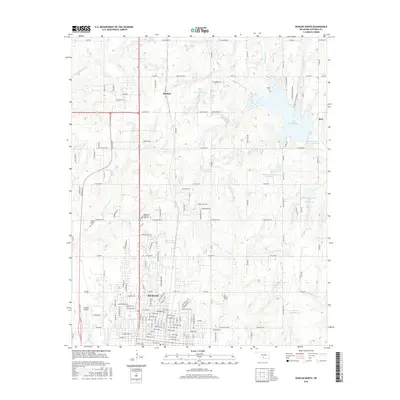
2016 Map of Duncan North
USGS Topo · Published 2016About this map
Lake Humphreys and a network of flood control reservoirs define the water-rich landscape between Marlow and the northern outskirts of Duncan in the mid-2010s. This USGS survey details the transition from urban street grids to a countryside punctuated by family-named landmarks and historical burial grounds. The map captures the significant water management infrastructure of the region, featuring multiple sites along Wildhorse Creek, including Wildhorse Creek Site 21 Reservoir and Wildhorse Creek Site 22 Reservoir.
Find a feature on this map
87 named features on this map. Tap any name to fly to it.
Don’t see what you’re looking for? This feature index may not catch every label — zoom into the map to look around manually.
Map Details
Editions of this 2016 Duncan North Map
This is the sole edition of this map. No revisions or reprints were ever made.
Other maps of this area

1901 · Addington
USGS Topo · 1:125,000

1902 · Rush Springs
USGS Topo · 1:125,000

1949 · Nellie
USGS Topo · 1:62,500

1950 · Marlow
USGS Topo · 1:62,500

1951 · Marlow
USGS Topo · 1:62,500

1955 · Lawton
USGS Topo · 1:250,000
1956 · Denton
USGS Topo · 1:24,000

1956 · Nellie
USGS Topo · 1:24,000

1956 · Nellie
USGS Topo · 1:62,500

1957 · Ardmore
USGS Topo · 1:250,000