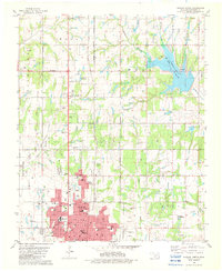
1982 Map of Duncan North
USGS Topo · Published 1982About this map
Duncan and Marlow anchor this early 1980s landscape, illustrating the expansion of these Stephens County communities along the north-south corridor. The map reveals a dense network of civic and religious life, from the Courthouse and City Hall in the city center to numerous neighborhood anchors like Lee Sch and Twain Sch. To the east, the impoundment of Lake Humphreys dominates the drainage of Wildhorse Creek and McCubbin Creek, creating a significant recreational focal point evidenced by the Campground and Boat Ramp.
Find a feature on this map
74 named features on this map. Tap any name to fly to it.
Don’t see what you’re looking for? This feature index may not catch every label — zoom into the map to look around manually.
Map Details
Editions of this 1982 Duncan North Map
This is the sole edition of this map. No revisions or reprints were ever made.
Other maps of this area

1901 · Addington
USGS Topo · 1:125,000

1902 · Rush Springs
USGS Topo · 1:125,000

1949 · Nellie
USGS Topo · 1:62,500

1950 · Marlow
USGS Topo · 1:62,500

1951 · Marlow
USGS Topo · 1:62,500

1955 · Lawton
USGS Topo · 1:250,000
1956 · Denton
USGS Topo · 1:24,000

1956 · Nellie
USGS Topo · 1:24,000

1956 · Nellie
USGS Topo · 1:62,500

1957 · Ardmore
USGS Topo · 1:250,000