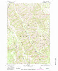
1964 Map of Duncan
USGS Topo · Published 1984About this map
Meacham Creek carves a deep valley through the Blue Mountains, serving as the primary corridor for the Union Pacific railroad. This 1964 survey (revised 1983) illustrates the remote character of northeastern Oregon, where the tiny settlements of Gibbon and Duncan anchor a landscape defined by sharp ridges and seasonal springs. The territory is largely managed as the Umatilla National Forest, with the Umatilla Indian Reservation Boundary cutting across the northwestern corner. Notable landmarks like the Duncan Guard Station and named terrain such as Black Canyon Butte and Horse Heaven Ridge reflect the area's history of forestry and livestock grazing. Numerous named water sources, including Little Squaw Spring and Buck Spring, suggest the critical importance of water access in this high-elevation environment.
Find a feature on this map
37 named features on this map. Tap any name to fly to it.
Don’t see what you’re looking for? This feature index may not catch every label — zoom into the map to look around manually.
Map Details
Editions of this 1964 Duncan Map
3 editions found
Other maps of this area

1953 · Pendleton
USGS Topo · 1:250,000

1956 · Pendleton
USGS Topo · 1:250,000

1963 · Meacham Lake
USGS Topo · 1:24,000

1963 · Bingham Springs
USGS Topo · 1:24,000

1964 · Thorn Hollow
USGS Topo · 1:24,000

1964 · Duncan
USGS Topo · 1:24,000

1964 · Thimbleberry Mtn
USGS Topo · 1:24,000

1964 · Gibbon
USGS Topo · 1:24,000

1964 · Huron
USGS Topo · 1:24,000

1964 · Drumhill Ridge
USGS Topo · 1:24,000