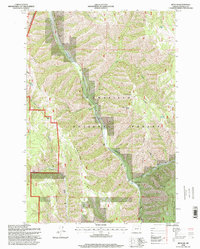
1995 Map of Duncan
USGS Topo · Published 1998About this map
Union Pacific rail lines follow the winding course of Meacham Creek through the heart of the Umatilla National Forest, illustrating the vital role of water-level corridors in navigating the Blue Mountains. This mid-1990s documentation captures the rugged geography of Umatilla County as it transitions across the Oregon Base Line. Small settlements and staging points like Gibbon and Duncan appear along the rail route, surrounded by steep drainages such as Duncan Canyon and Black Canyon. The landscape is defined by its dramatic verticality, from the high peak of Wilbur Mountain to the sharp profiles of Gibbon Ridge and Horseshoe Ridge. Numerous water sources, including Little Squaw Spring and Buck Spring, are noted throughout the forest, marking essential landmarks for surveyors and local land managers in this heavily timbered region.
Find a feature on this map
29 named features on this map. Tap any name to fly to it.
Don’t see what you’re looking for? This feature index may not catch every label — zoom into the map to look around manually.
Map Details
Editions of this 1995 Duncan Map
This is the sole edition of this map. No revisions or reprints were ever made.
Other maps of this area

1953 · Pendleton
USGS Topo · 1:250,000

1956 · Pendleton
USGS Topo · 1:250,000

1963 · Meacham Lake
USGS Topo · 1:24,000

1963 · Bingham Springs
USGS Topo · 1:24,000

1964 · Thorn Hollow
USGS Topo · 1:24,000

1964 · Duncan
USGS Topo · 1:24,000

1964 · Thimbleberry Mtn
USGS Topo · 1:24,000

1964 · Gibbon
USGS Topo · 1:24,000

1964 · Huron
USGS Topo · 1:24,000

1964 · Drumhill Ridge
USGS Topo · 1:24,000