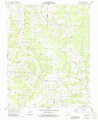
1956 Map of Duncan
USGS Topo · Published 1985About this map
Duncan serves as a central hub for this rural Missouri landscape, situated near the intersection of Webster Co and Wright Co. The 1956 field survey reveals a high density of community centers, notably a series of rural schools such as Washington Sch and Fairview Sch that likely anchored local farming neighborhoods. The terrain is defined by the headwaters of several drainages, including Cantrell Creek and the Woods Fk Gasconade R, which carve through the townships of Niangua and Gasconade.
Find a feature on this map
25 named features on this map. Tap any name to fly to it.
Don’t see what you’re looking for? This feature index may not catch every label — zoom into the map to look around manually.
Map Details
Editions of this 1956 Duncan Map
2 editions found
Other maps of this area

1939 · Fordland
USGS Topo · 1:62,500

1942 · Fordland
USGS Topo · 1:62,500

1946 · Niangua
USGS Topo · 1:62,500

1948 · Niangua
USGS Topo · 1:62,500

1951 · Mansfield NE
USGS Topo · 1:24,000

1951 · Mansfield NW
USGS Topo · 1:24,000

1954 · Springfield
USGS Topo · 1:250,000

1956 · Duncan
USGS Topo · 1:24,000

1956 · Rader
USGS Topo · 1:24,000
1956 · Hartville
USGS Topo · 1:24,000