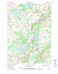
1974 Map of Dundee
USGS Topo · Published 1989About this map
Glacial geology and public lands define this 1970s landscape on the Fond du Lac and Sheboygan County line. The Kettle Moraine formation dominates the topography, characterized by a complex network of ridges, hills like McMullen Hill, and numerous water bodies including Long Lake, Cedar Lake, and the isolated Spruce Lake. This natural setting is home to the Spruce Lake Bog National Natural Landmark, protected within the broader Osceola State Forest. Settlement patterns are centered around the village of Dundee and the crossroads at Armstrong and Graham Corners. The Milwaukee Road railroad cuts through the southern terrain, while the Kettle Moraine Correctional Institute stands as a significant mid-century institutional landmark near Watercress Creek. Local history is preserved in several small burial grounds, such as Union Cem and Mitchell Cem, located amidst the region's numerous gravel pits and winding rural routes like Happy Hollow Road.
Find a feature on this map
62 named features on this map. Tap any name to fly to it.
Don’t see what you’re looking for? This feature index may not catch every label — zoom into the map to look around manually.
Map Details
Editions of this 1974 Dundee Map
2 editions found
Other maps of this area

1910 · Fond du Lac
USGS Topo · 1:62,500

1954 · Kiel
USGS Topo · 1:62,500

1955 · Campbellsport
USGS Topo · 1:62,500

1955 · Kewaskum
USGS Topo · 1:62,500

1955 · Fond Du Lac
USGS Topo · 1:62,500

1957 · Madison
USGS Topo · 1:250,000

1960 · Madison
USGS Topo · 1:250,000

1974 · St. Cloud
USGS Topo · 1:24,000
1974 · Elkhart Lake
USGS Topo · 1:24,000
1974 · Dundee
USGS Topo · 1:24,000