1956 Map of Dundee
USGS Topo · Published 1993About this map
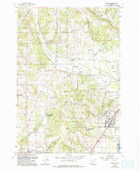
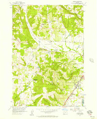
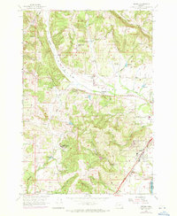
Chehalem Valley and its surrounding uplands appear here in a transition between their agricultural roots and modern development, reflecting data compiled as early as 1954 and revised through 1989. The prominent Red Hills and Ribbon Ridge dominate the landscape, providing the distinct topography that defines the region's character. In the southern corner, the city of Dundee sits along the Southern Pacific railroad line, while Lafayette marks the western edge of the survey. Cultural landmarks such as the Trappist Abbey of Our Lady of Guadalupe and the West Chehalem (Site) offer specific points of interest for local historians. This era shows an landscape of evolving transit, with several Landing Strips appearing among the traditional Quarries and Gravel Pits, while the Ewing Young Historical Marker near Ewing Young School preserves the area's pioneer heritage.
Find a feature on this map
49 named features on this map. Tap any name to fly to it.
Don’t see what you’re looking for? This feature index may not catch every label — zoom into the map to look around manually.
Map Details
Editions of this 1956 Dundee Map
3 editions found
Other maps of this area

1916 · Tualatin
USGS Topo · 1:62,500

1923 · Mount Angel
USGS Topo · 1:62,500

1924 · Mc Minnville
USGS Topo · 1:48,000

1926 · Mc Minnville
USGS Topo · 1:62,500

1939 · Tualatin
USGS Topo · 1:62,500

1940 · McMinnville
USGS Topo · 1:62,500

1940 · Tualatin
USGS Topo · 1:62,500

1940 · Mount Angel
USGS Topo · 1:62,500

1941 · Yamhill
USGS Topo · 1:62,500

1942 · Yamhill
USGS Topo · 1:62,500