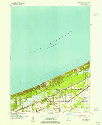
1953 Map of Dune Acres
USGS Topo · Published 1961About this map
Indiana Dunes State Park dominates the shoreline of Lake Michigan in this mid-century survey of Porter County. The map details a landscape where massive coastal formations like Mt Tom, Mt Holden, and Mt Jackson rise abruptly from the lakefront, bisected by the winding path of Dunes Creek. The southern half of the quadrangle reveals a concentrated transportation corridor, with the Chicago South Shore and South Bend Railroad and the New York Central providing vital links through the region. Local history is anchored by the presence of the Bailey Cem and Burstrom Cem near Baileytown, while established residential pockets like Beverly Shores and Dune Acres appear nestled between the dunes and the inland marshes.
Find a feature on this map
26 named features on this map. Tap any name to fly to it.
Don’t see what you’re looking for? This feature index may not catch every label — zoom into the map to look around manually.
Map Details
Editions of this 1953 Dune Acres Map
2 editions found
Other maps of this area

1934 · Porter
USGS Topo · 1:48,000

1940 · Porter
USGS Topo · 1:62,500

1953 · Garyton
USGS Topo · 1:24,000

1953 · Westville
USGS Topo · 1:24,000

1953 · Ogden Dunes
USGS Topo · 1:24,000

1953 · Chesterton
USGS Topo · 1:24,000

1953 · Dune Acres
USGS Topo · 1:24,000

1953 · Michigan City West
USGS Topo · 1:24,000

1953 · Chicago
USGS Topo · 1:250,000

1957 · Chicago
USGS Topo · 1:250,000