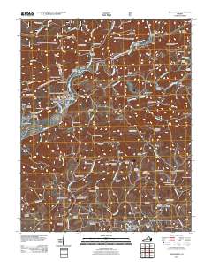
2011 Map of Dungannon
USGS Topo · Published 2011About this map
The Clinch River meanders through the heart of this Scott County landscape, defining the layout of rural hamlets and infrastructure. Near the bend in the river, the town of Dungannon sits as a central hub, flanked by the Virginia State Prison Camp and the river-bound terrain of Stony Island. The map reveals a dense network of family-named cemeteries and landmarks that reflect generations of local history, including the Osborne-Taylor Cemetery, Williams-Kilgore Cemetery, and the McConnell Cemetery.
Find a feature on this map
90 named features on this map. Tap any name to fly to it.
Don’t see what you’re looking for? This feature index may not catch every label — zoom into the map to look around manually.
Map Details
Editions of this 2011 Dungannon Map
This is the sole edition of this map. No revisions or reprints were ever made.
Other maps of this area

1894 · Estillville
USGS Topo · 1:125,000

1897 · Bristol
USGS Topo · 1:125,000

1902 · Bristol
USGS Topo · 1:125,000

1920 · Wise
USGS Topo · 1:48,000

1920 · Coeburn
USGS Topo · 1:48,000

1921 · Wise
USGS Topo · 1:62,500

1935 · Hilton
USGS Topo · 1:24,000
1935 · Wise
USGS Topo · 1:24,000

1935 · Moggasin
USGS Topo · 1:48,000

1935 · Mendota
USGS Topo · 1:24,000