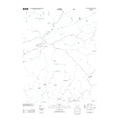
2013 Map of Dungannon
USGS Topo · Published 2013About this map
Dungannon sits at a strategic bend where the Clinch River meets Wolf Run Cr, anchoring a landscape shaped by narrow valleys and steep ridges. The 2013 topography reveals a network of small communities and rural intersections, including the Virginia State Prison Camp and the rail-oriented Miller Yard to the northeast. To the south, Nickelsville serves as another focal point of settlement, connected by winding roads like Bush Mill Rd that lead past the historic Bush Mill site. This map documents a region defined by its named hollows and gaps, such as Muttonhead Hollow and Pound Gap, which reflect long-standing local nomenclature and the difficult terrain of the Appalachian highlands. The presence of Grigsby Store and the remote settlement at Twin Springs highlights the persistent, decentralized nature of commerce and community in this part of Scott County.
Find a feature on this map
83 named features on this map. Tap any name to fly to it.
Don’t see what you’re looking for? This feature index may not catch every label — zoom into the map to look around manually.
Map Details
Editions of this 2013 Dungannon Map
This is the sole edition of this map. No revisions or reprints were ever made.
Other maps of this area

1894 · Estillville
USGS Topo · 1:125,000

1897 · Bristol
USGS Topo · 1:125,000

1902 · Bristol
USGS Topo · 1:125,000

1920 · Wise
USGS Topo · 1:48,000

1920 · Coeburn
USGS Topo · 1:48,000

1921 · Wise
USGS Topo · 1:62,500

1935 · Hilton
USGS Topo · 1:24,000
1935 · Wise
USGS Topo · 1:24,000

1935 · Moggasin
USGS Topo · 1:48,000

1935 · Mendota
USGS Topo · 1:24,000