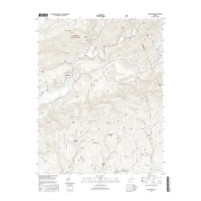
2016 Map of Dungannon
USGS Topo · Published 2016About this map
The Clinch River carves through the Appalachian landscape, anchoring a region of small settlements and family-named ridges. Along its banks, Dungannon serves as a primary hub, while smaller locales like Stony and Mill Island follow the river's path northward toward the Jefferson National Forest. This terrain is deeply marked by its burial grounds, with dozens of family sites like the Osborne-Taylor Cem and Hillman Cem scattered across the uplands, providing a high-density map for genealogical research. To the south, Nickelsville sits near Copper Creek, connected to the interior by roads such as Blackjack Dr and Racepath Dr. The landscape is a network of hollows, including Beaver Hollow and Muttonhead Hollow, which demonstrate the traditional Appalachian settlement patterns where communities and homes were concentrated in narrow valleys between ridges like Chesnut Ridge.
Find a feature on this map
129 named features on this map. Tap any name to fly to it.
Don’t see what you’re looking for? This feature index may not catch every label — zoom into the map to look around manually.
Map Details
Editions of this 2016 Dungannon Map
This is the sole edition of this map. No revisions or reprints were ever made.
Other maps of this area

1894 · Estillville
USGS Topo · 1:125,000

1897 · Bristol
USGS Topo · 1:125,000

1902 · Bristol
USGS Topo · 1:125,000

1920 · Wise
USGS Topo · 1:48,000

1920 · Coeburn
USGS Topo · 1:48,000

1921 · Wise
USGS Topo · 1:62,500

1935 · Hilton
USGS Topo · 1:24,000
1935 · Wise
USGS Topo · 1:24,000

1935 · Moggasin
USGS Topo · 1:48,000

1935 · Mendota
USGS Topo · 1:24,000