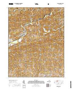
2019 Map of Dungannon
USGS Topo · Published 2019About this map
The Clinch River carves a deep path through this corner of the Appalachian mountains, where the town of Dungannon sits at a pivotal river bend. The landscape is defined by its deep hollows and high ridges, including Copper Ridge and Osborne Ridge, which separate the river valley from the rolling terrain of Crackers Neck. Much of the northern area is preserved within the Jefferson National Forest, featuring landmarks like Hanging Rock and Pound Gap, while the Chief Benge Scout Trail and Little Stony NRT provide access to the high elevations of Bald Rock.
Find a feature on this map
144 named features on this map. Tap any name to fly to it.
Don’t see what you’re looking for? This feature index may not catch every label — zoom into the map to look around manually.
Map Details
Editions of this 2019 Dungannon Map
This is the sole edition of this map. No revisions or reprints were ever made.
Other maps of this area

1894 · Estillville
USGS Topo · 1:125,000

1897 · Bristol
USGS Topo · 1:125,000

1902 · Bristol
USGS Topo · 1:125,000

1920 · Wise
USGS Topo · 1:48,000

1920 · Coeburn
USGS Topo · 1:48,000

1921 · Wise
USGS Topo · 1:62,500

1935 · Hilton
USGS Topo · 1:24,000
1935 · Wise
USGS Topo · 1:24,000

1935 · Moggasin
USGS Topo · 1:48,000

1935 · Mendota
USGS Topo · 1:24,000