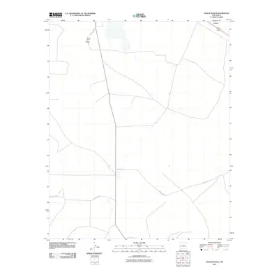
2010 Map of Dunlap Ranch
USGS Topo · Published 2010About this map
Dunlap Ranch and the associated Estancia 1 Kellogg site anchor this high-desert landscape in Torrance County, New Mexico. The map reveals a sparse but deliberate network of rural infrastructure, where long straight stretches of County Rd C073 and County Rd C067 intersect across the plateau. To the northeast, the settlement of Carnero sits along a primary corridor, marking a point of transition in an otherwise open ranching environment. The surveying of these land divisions and county routes illustrates the organized nature of modern land management in the Southwest, where property lines and service roads like County Rd C071 define the human footprint on the vast New Mexico terrain.
Find a feature on this map
7 named features on this map. Tap any name to fly to it.
Don’t see what you’re looking for? This feature index may not catch every label — zoom into the map to look around manually.
Map Details
Editions of this 2010 Dunlap Ranch Map
This is the sole edition of this map. No revisions or reprints were ever made.
Other maps of this area

1954 · Fort Sumner
USGS Topo · 1:250,000

1958 · Fort Sumner
USGS Topo · 1:250,000

1978 · Santa Barbara Lake
USGS Topo · 1:24,000

1978 · Tejon
USGS Topo · 1:24,000

1978 · Encino
USGS Topo · 1:24,000

1978 · Negra SE
USGS Topo · 1:24,000

1978 · Negra
USGS Topo · 1:24,000

1978 · Dunlap Ranch
USGS Topo · 1:24,000

1980 · Corona
USGS Topo · 1:100,000
1981 · Duran
USGS Topo · 1:24,000