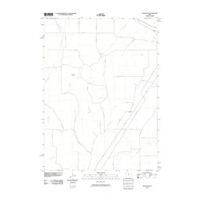
2010 Map of Dunlap SW
USGS Topo · Published 2010About this map
The Boyer River corridor defines the eastern landscape of this Harrison County region, providing a natural drainage route that has long influenced the placement of local roads and property boundaries. The small settlement of Baird sits tucked against the river, a central point in an extensive grid of agricultural land connected by a network of gravel and dirt roads. These thoroughfares, such as Quay Ave and Panora Ave, cross over several significant waterways including Willow Creek, Mud Creek, and Thompson Creek. For genealogists and local historians, the placement of Cleveland Cemetery and Valley View Cemetery provides essential anchor points for tracing family lineages in this rural section of Iowa. The map illustrates a landscape of steady agricultural production and hydrological management, where the movement of water through systems like Mill Creek and Pleayune Creek remains as vital to the community as the local road network.
Find a feature on this map
37 named features on this map. Tap any name to fly to it.
Don’t see what you’re looking for? This feature index may not catch every label — zoom into the map to look around manually.
Map Details
Editions of this 2010 Dunlap SW Map
This is the sole edition of this map. No revisions or reprints were ever made.
Other maps of this area

1954 · Omaha
USGS Topo · 1:250,000

1957 · Omaha
USGS Topo · 1:250,000

1958 · Omaha
USGS Topo · 1:250,000

1970 · Logan
USGS Topo · 1:24,000

1971 · Moorhead SE
USGS Topo · 1:24,000

1971 · Dunlap SW
USGS Topo · 1:24,000

1971 · Dunlap
USGS Topo · 1:24,000
1971 · Moorhead
USGS Topo · 1:24,000
1971 · Dunlap NE
USGS Topo · 1:24,000
1971 · Dunlap NW
USGS Topo · 1:24,000