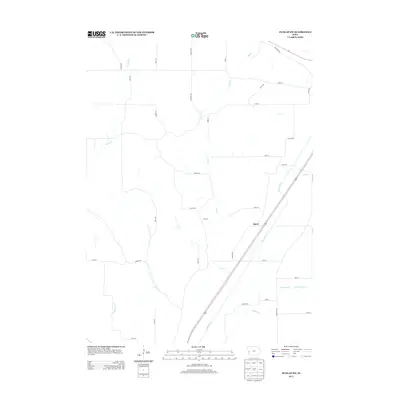
2013 Map of Dunlap SW
USGS Topo · Published 2013About this map
The settlement of Baird sits at the heart of this Harrison County landscape, positioned along the prominent corridor of the Boyer River. The river valley serves as the primary geographic axis, drawing a sharp diagonal through an area defined by its intricate drainage networks. Numerous small waterways including Mud Creek, Willow Creek, and Mill Creek feed into the larger river system, while Picayune Creek and North Picayune Creek carve through the southern reaches of the quadrangle. The road system follows a distinct grid-and-valley pattern, with family and place-named routes like Nelson Hollow and Sawyer Trail providing access to the agricultural uplands. This 2013 survey reveals the persistent rural character of the region, where transportation routes and early settlement locations remain tied to the natural hydrology of the Boyer River valley.
Find a feature on this map
39 named features on this map. Tap any name to fly to it.
Don’t see what you’re looking for? This feature index may not catch every label — zoom into the map to look around manually.
Map Details
Editions of this 2013 Dunlap SW Map
This is the sole edition of this map. No revisions or reprints were ever made.
Other maps of this area

1954 · Omaha
USGS Topo · 1:250,000

1957 · Omaha
USGS Topo · 1:250,000

1958 · Omaha
USGS Topo · 1:250,000

1970 · Logan
USGS Topo · 1:24,000

1971 · Moorhead SE
USGS Topo · 1:24,000

1971 · Dunlap SW
USGS Topo · 1:24,000

1971 · Dunlap
USGS Topo · 1:24,000
1971 · Moorhead
USGS Topo · 1:24,000
1971 · Dunlap NE
USGS Topo · 1:24,000
1971 · Dunlap NW
USGS Topo · 1:24,000