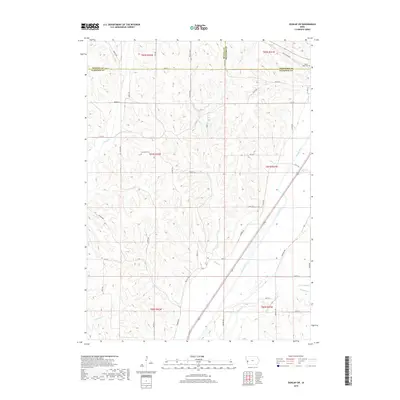
2018 Map of Dunlap SW
USGS Topo · Published 2018About this map
The rolling hills and drainage basins of the western Iowa loess hills are documented here at the convergence of Harrison, Monona, and Crawford counties. The agricultural landscape is bisected by the broad valley of the Boyer River, which flows southwest alongside a network of local roads such as Salina Ave and Spokane Ave. This 2018 survey reveals the persistent imprint of nineteenth-century settlement patterns in the form of rural burial grounds, specifically Cleveland Cem and Valley View Cem, which remain tucked into the township sections. The terrain is defined by a dense system of waterways including Willow Cr, Mud Cr, and the northern reach of Thompson Cr, each carving out the distinctive draws and hollows that characterize this portion of the Missouri River watershed, such as the prominent Nelson Hollow in the northeast quadrant.
Find a feature on this map
47 named features on this map. Tap any name to fly to it.
Don’t see what you’re looking for? This feature index may not catch every label — zoom into the map to look around manually.
Map Details
Editions of this 2018 Dunlap SW Map
This is the sole edition of this map. No revisions or reprints were ever made.
Other maps of this area

1954 · Omaha
USGS Topo · 1:250,000

1957 · Omaha
USGS Topo · 1:250,000

1958 · Omaha
USGS Topo · 1:250,000

1970 · Logan
USGS Topo · 1:24,000

1971 · Moorhead SE
USGS Topo · 1:24,000

1971 · Dunlap SW
USGS Topo · 1:24,000

1971 · Dunlap
USGS Topo · 1:24,000
1971 · Moorhead
USGS Topo · 1:24,000
1971 · Dunlap NE
USGS Topo · 1:24,000
1971 · Dunlap NW
USGS Topo · 1:24,000