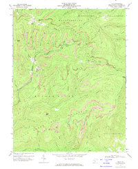
1972 Map of Duo
USGS Topo · Published 1974About this map
Duo sits at the heart of this industrial and mountain landscape, where the heavy extraction of the early 1970s is etched into the terrain of Meadow Bluff Mountain. Extensive strip mines, active mines, and a prominent slag dump surround the settlement, illustrating the intensive coal operations of the era. The land is defined by high peaks and sharp ridges, including Beech Knob and Job Knob, which overlook the complex drainage systems of the Little Clear Creek and the North Fork. Within the Monongahela National Forest, a network of primitive roads and the National Forest Trail connect isolated features like Kuhn Glades and various tipples. This survey documents a specific moment when high-altitude mining intersected with the protected forest lands of Greenbrier County.
Find a feature on this map
55 named features on this map. Tap any name to fly to it.
Don’t see what you’re looking for? This feature index may not catch every label — zoom into the map to look around manually.
Map Details
Editions of this 1972 Duo Map
2 editions found
Other maps of this area

1887 · Hinton
USGS Topo · 1:125,000

1887 · Lewisburg
USGS Topo · 1:125,000

1889 · Nicholas
USGS Topo · 1:125,000

1891 · Lewisburg
USGS Topo · 1:125,000

1891 · Nicholas
USGS Topo · 1:125,000

1891 · Huntersville
USGS Topo · 1:125,000

1892 · Hinton
USGS Topo · 1:125,000

1894 · Huntersville
USGS Topo · 1:125,000

1901 · Nicholas
USGS Topo · 1:125,000

1918 · Richwood
USGS Topo · 1:62,500