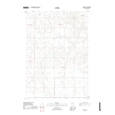
2017 Map of Dupree NE
USGS Topo · Published 2017About this map
The Moreau River meanders across this Ziebach County landscape, serving as the primary drainage for a network of prairie creeks in the northern Great Plains. Prominent local landmarks Gray Butte and Saint Patrick Butte rise above the surrounding terrain, providing significant navigational markers in this sparsely settled region. The map documents an intricate system of ephemeral and permanent waterways, including Ash Cr, Irish Cr, and Pretty Cr, which have carved out distinct topographical features like Sandrock Draw. The presence of Route 65 indicates the primary north-south transport corridor through these ranchlands. This survey illustrates the relationship between the river's path and the high buttes that define the horizon, reflecting the enduring rural character of western South Dakota at the start of the 21st century.
Find a feature on this map
13 named features on this map. Tap any name to fly to it.
Don’t see what you’re looking for? This feature index may not catch every label — zoom into the map to look around manually.
Map Details
Editions of this 2017 Dupree NE Map
This is the sole edition of this map. No revisions or reprints were ever made.
Other maps of this area

1951 · Dupree NE
USGS Topo · 1:24,000

1951 · Thunder Butte
USGS Topo · 1:24,000

1952 · Lantry NW
USGS Topo · 1:24,000

1953 · McIntosh
USGS Topo · 1:250,000

1958 · McIntosh
USGS Topo · 1:250,000

1978 · Isabel SW
USGS Topo · 1:24,000

1979 · Dupree
USGS Topo · 1:25,000

1981 · Lantry
USGS Topo · 1:24,000

1982 · Irish Creek SW
USGS Topo · 1:24,000
1982 · Irish Creek SE
USGS Topo · 1:24,000