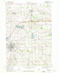
1969 Map of Durand
USGS Topo · Published 1971About this map
The railroad hub of Durand anchors this survey of the borderlands between Shiawassee and Genesee Counties. The Grand Trunk Western railroad is the defining industrial feature, cutting diagonally across the landscape and supporting the growth of the region's smaller hamlets like Lennon, Duffield, and Webb. The topography is defined by a complex network of agricultural drainage and natural waterways, including Misteguay Creek, Swartz Creek, and Webb Creek.
Find a feature on this map
62 named features on this map. Tap any name to fly to it.
Don’t see what you’re looking for? This feature index may not catch every label — zoom into the map to look around manually.
Map Details
Editions of this 1969 Durand Map
2 editions found
Other maps of this area

1917 · Chesaning
USGS Topo · 1:62,500

1919 · Burt
USGS Topo · 1:62,500

1921 · Burt
USGS Topo · 1:62,500

1922 · Durand
USGS Topo · 1:62,500

1926 · Corunna
USGS Topo · 1:62,500

1929 · Corunna
USGS Topo · 1:62,500

1943 · Burt
USGS Topo · 1:62,500

1943 · Chesaning
USGS Topo · 1:62,500

1943 · Durand
USGS Topo · 1:62,500

1944 · Corunna
USGS Topo · 1:62,500