1954 Map of Durango
USGS Topo · Published 1954About this map
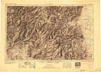
The San Juan Mountains and the Continental Divide dominate this mid-century view of southwestern Colorado, where the high-altitude mining legacy of Silverton, Telluride, and Rico is clearly mapped. The rugged terrain is bisected by the Denver and Rio Grande Western RR, which follows narrow river valleys to reach remote outposts. In the south, the landscape transitions from the jagged Needle Mountains into the lands of the Southern Ute Indian Reservation and Jicarilla Apache Indian Reservation. The presence of the Vallecito Reservoir and the extensive network of the Rio Grande National Forest highlights the importance of water management and federal land stewardship in the post-war West. Small rural landmarks like Bronson School and Carmel School provide granular detail for local historians, while the confluence of the Animas River and San Juan River defines the southern drainage patterns toward New Mexico.
Find a feature on this map
62 named features on this map. Tap any name to fly to it.
Don’t see what you’re looking for? This feature index may not catch every label — zoom into the map to look around manually.
Map Details
Editions of this 1954 Durango Map
2 editions found

Other maps of this area

1889 · Largo
USGS Topo · 1:250,000

1889 · Chaco
USGS Topo · 1:250,000

1892 · Chaco
USGS Topo · 1:250,000

1895 · Largo
USGS Topo · 1:250,000

1895 · La Plata
USGS Topo · 1:62,500

1897 · La Plata
USGS Topo · 1:62,500

1897 · Rico
USGS Topo · 1:62,500

1897 · Telluride
USGS Topo · 1:62,500

1897 · Silverton
USGS Topo · 1:62,500

1898 · Durango
USGS Topo · 1:62,500