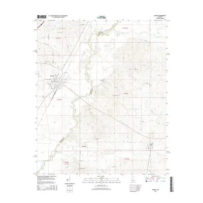
2015 Map of Durant
USGS Topo · Published 2015About this map
The Big Black River forms a winding natural boundary through the center of this landscape, separating the counties of Holmes and Attala. To the west, the town of Durant serves as a regional hub with a distinct street grid including Castalian Springs Rd, Martin Luther King Dr, and SW Depot St. The surrounding countryside is defined by small settlements like Boyette and Sallis, the latter situated near the confluence of Long Cr and Taylor Cr. Genealogists will find a high density of family and community burial sites scattered across the hills and river bottoms, such as Melton Cem, Holleman Cem, and Stump Ridge Cem. The presence of oxbow features like Round Lake along the river's path highlights the dynamic hydrology of the region as it appeared in the mid-2010s.
Find a feature on this map
42 named features on this map. Tap any name to fly to it.
Don’t see what you’re looking for? This feature index may not catch every label — zoom into the map to look around manually.
Map Details
Editions of this 2015 Durant Map
This is the sole edition of this map. No revisions or reprints were ever made.
Other maps of this area

1953 · Meridian
USGS Topo · 1:250,000

1953 · West Point
USGS Topo · 1:250,000

1957 · Meridian
USGS Topo · 1:250,000

1958 · West Point
USGS Topo · 1:250,000

1962 · Thomastown
USGS Topo · 1:62,500

1963 · West Point
USGS Topo · 1:250,000

1964 · West
USGS Topo · 1:24,000
1964 · Bowling Green
USGS Topo · 1:24,000

1964 · Hesterville
USGS Topo · 1:24,000

1964 · Newport
USGS Topo · 1:24,000