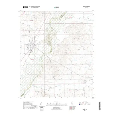
2018 Map of Durant
USGS Topo · Published 2018About this map
Durant serves as the primary urban hub on this Mississippi landscape, where the modern path of I-55 intersects with the established local street grid, including N Jackson St and E Madison St. The town's layout reflects its growth near the wetlands of the Big Black River, which forms the winding boundary between Holmes and Attala counties. The map records numerous family and community burial grounds, such as Holeman Cem and Melton Cem, scattered across the undulating terrain between the river bottom and the higher ground toward Sallis. Small settlements like Boyette and natural features like Round Lake provide clear evidence of the rural settlement patterns that persist alongside the more developed corridors. Waterways like Apookta Creek and Long Cr define the drainage of this region, shaping the placement of early roads and cemeteries.
Find a feature on this map
75 named features on this map. Tap any name to fly to it.
Don’t see what you’re looking for? This feature index may not catch every label — zoom into the map to look around manually.
Map Details
Editions of this 2018 Durant Map
This is the sole edition of this map. No revisions or reprints were ever made.
Other maps of this area

1953 · Meridian
USGS Topo · 1:250,000

1953 · West Point
USGS Topo · 1:250,000

1957 · Meridian
USGS Topo · 1:250,000

1958 · West Point
USGS Topo · 1:250,000

1962 · Thomastown
USGS Topo · 1:62,500

1963 · West Point
USGS Topo · 1:250,000

1964 · West
USGS Topo · 1:24,000
1964 · Bowling Green
USGS Topo · 1:24,000

1964 · Hesterville
USGS Topo · 1:24,000

1964 · Newport
USGS Topo · 1:24,000