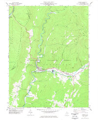
1977 Map of Durbin
USGS Topo · Published 1977About this map
The convergence of the Western Maryland and Chesapeake and Ohio railroads defines the mid-century mountain economy of this Pocahontas County landscape. Situated along the East Fork Greenbrier River, the town of Durbin serves as a central hub for the surrounding settlements of Frank, Bartow, and Nottingham. The map records a curious mix of traditional rural life and modern industry, noting the isolated Burner Settlement alongside industrial markers like a Radio Tower, Industrial Waste Ponds, and a Drive-in Theater.
Find a feature on this map
57 named features on this map. Tap any name to fly to it.
Don’t see what you’re looking for? This feature index may not catch every label — zoom into the map to look around manually.
Map Details
Editions of this 1977 Durbin Map
2 editions found
Other maps of this area

1889 · Beverly
USGS Topo · 1:125,000

1892 · Beverly
USGS Topo · 1:125,000

1901 · Monterey
USGS Topo · 1:125,000

1922 · Spruce Knob
USGS Topo · 1:48,000

1922 · Cass
USGS Topo · 1:48,000

1922 · Durbin
USGS Topo · 1:48,000

1924 · Cass
USGS Topo · 1:62,500

1924 · Durbin
USGS Topo · 1:62,500

1924 · Spruce Knob
USGS Topo · 1:62,500

1941 · Monterey
USGS Topo · 1:62,500