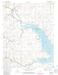
1971 Map of Durham
USGS Topo · Published 1985About this map
Durham sits at the junction of the St Louis and Southwestern railroad lines, serving as a hub for the agricultural and extractive landscape of Marion County. The expansive Marion Lake dominates the eastern half of the map, having transformed the valley where the North Cottonwood River, Silver Creek, and French Creek converge. This 1970s-era documentation shows the area as a significant conservation and recreation zone, featuring the Marion Lake State Wildlife Area and specialized zones like the Marion Lake State Waterfowl Refuge. Rural life is evidenced by a network of family and community landmarks, including the Suncrest Sch and several historic burial grounds such as Frick Cem and Johannestal Cem. The presence of the Durham Oil and Gas Field indicates the industrial layer of the local economy alongside traditional farming.
Find a feature on this map
28 named features on this map. Tap any name to fly to it.
Don’t see what you’re looking for? This feature index may not catch every label — zoom into the map to look around manually.
Map Details
Editions of this 1971 Durham Map
2 editions found
Other maps of this area

1889 · Newton
USGS Topo · 1:125,000

1889 · Abilene
USGS Topo · 1:125,000

1894 · Newton
USGS Topo · 1:125,000

1894 · Abilene
USGS Topo · 1:125,000

1955 · Hutchinson
USGS Topo · 1:250,000

1959 · Hutchinson
USGS Topo · 1:250,000

1964 · Ramona
USGS Topo · 1:24,000
1964 · Gypsum SE
USGS Topo · 1:24,000
1964 · Tampa
USGS Topo · 1:24,000

1971 · Durham
USGS Topo · 1:24,000