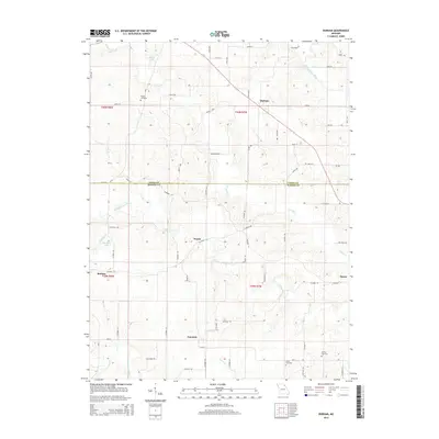
2014 Map of Durham
USGS Topo · Published 2014About this map
The Middle Fabius River and South Fabius River define the undulating landscape along the border of Lewis and Marion Counties. This rural region is characterized by small, scattered settlements like Durham and Emerson, which serve as anchor points for a network of country roads including Mo-Aa and Mo-N. The land is deeply etched by a complex drainage system featuring Troublesome Creek, Grassy Cr, and Pigeon Cr, creating a varied topography of ridges and bottoms. For those researching local families, the presence of several established burial grounds such as Wagner Cemetery, Banks Cemetery, and McPike Cemetery offers significant genealogical value. Traces of smaller communities or former post office locations like Naomi, Benbow, and Hester appear throughout the township grids, while Speckhart Lake and Klocke Lake provide distinct water landmarks in an area otherwise dominated by agricultural river valleys.
Find a feature on this map
74 named features on this map. Tap any name to fly to it.
Don’t see what you’re looking for? This feature index may not catch every label — zoom into the map to look around manually.
Map Details
Editions of this 2014 Durham Map
This is the sole edition of this map. No revisions or reprints were ever made.
Other maps of this area

1903 · Kahoka
USGS Topo · 1:125,000

1903 · Palmyra
USGS Topo · 1:125,000

1948 · Quincy
USGS Topo · 1:250,000

1949 · Durham
USGS Topo · 1:24,000

1949 · Maywood
USGS Topo · 1:24,000

1949 · Palmyra
USGS Topo · 1:24,000

1949 · Philadelphia
USGS Topo · 1:24,000
1950 · Maywood
USGS Topo · 1:24,000

1950 · Durham
USGS Topo · 1:24,000

1950 · Palmyra
USGS Topo · 1:24,000