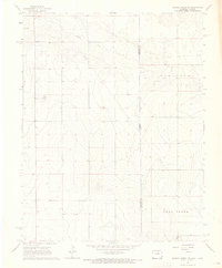
1966 Map of Durkee Creek NE
USGS Topo · Published 1967About this map
The high plains of the Colorado-Kansas border define this 1966 topographic study, where the arid landscape of Prowers and Hamilton Counties meets at the state line. The terrain is shaped by the drainage of Bear Creek in the south and the Coolidge region to the north, reflecting a sparse, rural environment focused on water management and infrastructure. Traces of early land use are visible through an Abandoned canal segment and a network of widely spaced wells and windmills, essential for life in this high-altitude steppe.
Find a feature on this map
9 named features on this map. Tap any name to fly to it.
Don’t see what you’re looking for? This feature index may not catch every label — zoom into the map to look around manually.
Map Details
Editions of this 1966 Durkee Creek NE Map
This is the sole edition of this map. No revisions or reprints were ever made.
Other maps of this area

1890 · Granada
USGS Topo · 1:125,000

1891 · Albany
USGS Topo · 1:125,000

1892 · Granada
USGS Topo · 1:125,000

1893 · Albany
USGS Topo · 1:125,000

1894 · Granada
USGS Topo · 1:125,000

1900 · Syracuse
USGS Topo · 1:125,000

1920 · Syracuse
USGS Topo · 1:125,000

1953 · Holly West
USGS Topo · 1:24,000

1953 · Holly East
USGS Topo · 1:24,000

1954 · Lamar
USGS Topo · 1:250,000