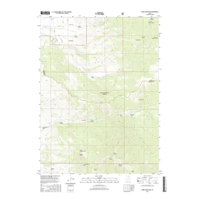
2017 Map of Durst Mountain
USGS Topo · Published 2017About this map
Abbey of the Holy Trinity Cem and the nearby Monastery Spring occupy the northern reaches of this landscape, situated near the S Br S Fork Ogden River. This high-altitude terrain in Cache National Forest is defined by complex drainages and significant peaks, including Little Mahogany Mtn, Big Mahogany Mtn, and the prominent Durst Mountain. The map details the transition between Weber and Morgan counties, following the crests of ridges and deep incisions of Cottonwood Canyon and Magpie Canyon. Numerous seasonal and perennial water sources such as Sulphur Springs, Spring Br, and Durst Spring dot the mountain slopes, while named hollows like Bohman Hollow and Deadman Gulch reveal the local nomenclature of this high-country wilderness.
Find a feature on this map
43 named features on this map. Tap any name to fly to it.
Don’t see what you’re looking for? This feature index may not catch every label — zoom into the map to look around manually.
Map Details
Editions of this 2017 Durst Mountain Map
This is the sole edition of this map. No revisions or reprints were ever made.
Other maps of this area

1954 · Ogden
USGS Topo · 1:250,000

1955 · Peterson
USGS Topo · 1:24,000

1955 · Huntsville
USGS Topo · 1:24,000

1955 · Snow Basin
USGS Topo · 1:24,000

1958 · Ogden
USGS Topo · 1:250,000

1960 · Ogden
USGS Topo · 1:250,000
1961 · Devils Slide
USGS Topo · 1:24,000
1961 · Morgan
USGS Topo · 1:24,000

1961 · Morgan
USGS Topo · 1:62,500
1964 · Browns Hole
USGS Topo · 1:24,000