
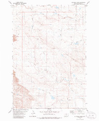
1979 Map of Dutchman Creek
USGS Topo · Published 1979About this map
Blue Mud Hills dominate the northern landscape of this southeastern Montana region, where a complex network of seasonal drainages shapes the high plains. The topography is defined by the convergence of several major creek systems, most notably Dutchman Creek and the various branches of Corral Creek, including the North Fork Corral Creek and South Fork Corral Creek. This 1970s survey captures a landscape primarily utilized for open-range ranching, evidenced by the numerous fence lines and section boundaries that crisscross the terrain.
Find a feature on this map
14 named features on this map. Tap any name to fly to it.
Don’t see what you’re looking for? This feature index may not catch every label — zoom into the map to look around manually.
Map Details
Editions of this 1979 Dutchman Creek Map
2 editions found
Other maps of this area

1954 · Ekalaka
USGS Topo · 1:250,000

1956 · Ekalaka
USGS Topo · 1:250,000

1958 · Ekalaka
USGS Topo · 1:250,000

1965 · Ekalaka
USGS Topo · 1:250,000

1979 · W L Butte
USGS Topo · 1:24,000

1979 · Dead Boy Divide
USGS Topo · 1:24,000

1979 · Ikey Creek
USGS Topo · 1:24,000

1979 · Chalk Buttes
USGS Topo · 1:24,000
1979 · Davis Creek East
USGS Topo · 1:24,000

1981 · Alzada
USGS Topo · 1:100,000